Infrastructures, territoires, transports, énergies, écosystèmes et paysages

L'actualité

Rechercher dans les projets

Le programme ITTECOP

ITTECOP est un programme de recherche créé en 2008 par le MTECT, en coordination avec l’Ademe, dans le cadre de la première stratégie nationale pour la biodiversité. Avec six appels à propo­sitions de recherche (2008, 2009, 2012, 2014, 2017 et 2020) et près de 100 projets soutenus, ITTECOP contribue à alimenter une réflexion forte sur l’intégration des ques­tions relatives aux écosystèmes et aux paysages lors de l’élaboration et de la réalisation de pro­jets d’infrastructures ou l’adaptation d’aménage­ments existants. Le programme aborde les infrastructures de transport terrestre dans leur diversité, qu’elles soient fluviales, ferrées, routières ou énergé­tiques ainsi que leurs interfaces avec les ter­ritoires : gares, ports ou aéroports. Les effets des ILTe sont analysés, selon leurs échelles, sous plusieurs angles complémentaires : éco­logiques, territoriaux, sociaux, économiques, paysagers ou patrimoniaux.

A partir de l'APR 2024, ITTECOP intègre les infrastructures d'énergie dans son champ de recherche.

Recevoir la lettre ITTECOP

Rechercher dans les actualités

La plateforme webdocumentaire interactive d'ITTECOP

webdoc home

La plaquette ITTECOP

Pilotes du programme

logo ecologieLogo ADEMEFRB 120CILBOffice Français de la Biodiversité

Partenaires du programme

ienelogo kheopslogo bison

Rechercher dans les projets

PROJETS DE RECHERCHE
D’une durée maximale de trois ans, les projets de recherche, visent à répondre à des questions scientifiques au travers d’approches pluridisciplinaires et d’un examen conjoint d’infrastructures linéaires de natures différentes. D’une durée maximale de trois ans, les projets de recherche, visent à répondre à des questions scientifiques au travers d’approches pluridisciplinaires et d’un examen conjoint d’infrastructures linéaires de natures différentes.
 
REVUE SYSTEMATIQUE
Au delà des jeux de données collectés à l’issue de travaux individuels ou de programmes de recherche limités, les « revues systématiques » permettent d’évaluer la quantité et la qualité (confiance) des savoirs disponibles afin d’en tirer des conclusions objectives et transparentes.
PROJET CESAB
Le Cesab invite à une nouvelle façon de faire de la recherche sur la biodiversité en exploitant mieux les données et les informations existantes.
PROJETS EXPLORATOIRES ET INCUBATOIRES
D’une durée maximale d’un an, les projets exploratoires visent à analyser de façon prospective des sujets émergents, controversés ou peu stabilisés, à la fois chez les opérateurs et dans la recherche fondamentale. Les projets incubatoires ont pour objectif d’aboutir au dépôt de projets de recherche ambitieux dans le cadre des appels ANR, H2020 ou Life+.


Projet
Type
FLEXI_PROJET_RECHERCHE
Etat
FLEXI_ACHEVE
FLEXI_ANNEE_APPEL
2014
FLEXI_SYNTHESE
FLEXI_OUI
FLEXI_CEREMA
FLEXI_OUI

DYNARP (2)

Dynamics and Management of Asian Knotweed at the Landscape Level, Impacts and Perceptions

Dynamics and Management of Asian Knotweed at the Landscape Level, Impacts and Perceptions


{Mp4} ITWDYNARP720 {/ mp4}

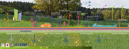
Linear transport infrastructures and their right-of-way (ILTe) constitute corridors facilitating or slowing down the circulation of species. The development of invasive alien species is generally linked to anthropogenic movements and can therefore be promoted by the presence and management of these ILTe. Ranked among the worst invasive alien species in Europe and North America, exotic knotweeds grow on ILTe and raise important issues in economic and environmental terms (management, security, biodiversity, etc.). Significant sums are invested for their management, with little feedback on the effectiveness of the different methods used or the role of these methods in the landscape dynamics of these species. This project is a continuation of research carried out at Irstea Grenoble and ENS Lyon. It is built and operated in partnership with the Cerema of L'Isle d'Abeau and is conducted with the support of the expertise of the design office Concept Cours d'Eau. It aims to assess how perception, management, environmental factors and the type of ILTe impact the dynamics of Asian knotweed at the landscape scale.

This project is conducted in parallel on three types of ILTe, road rights-of-way, railways and waterways. It is based on surveys of managers, the comparison of mapping accuracy from satellite, aerial and drone images, surveys of 48 stain boundaries at 5-year intervals, mapping of 8 study sites 1 km long and 200 m wide (totaling 574 spots) and the shared expertise of project researchers and experts for the production of management tools for managers.

The analysis of the photoquestionnaire shows a difference of perception of the different infrastructure managers in their reasons to act against the knotweed. There is also a certain discouragement among managers as to the inefficiency of control operations. The analysis of the remote sensing tools available reflects the difficulty of properly mapping the Knotweeds and in particular separating them from trees and shrubs. On the model landscapes studied, the shapes and stain patterns vary depending on the type of ILTe. The diachronic analysis of knotweed shows in particular a progression of the surfaces related to the initial size of the spots and the distance to a road or a river. There is little impact of mowing and ramet density depends on stain size and light availability. The joint expertise of the project's researchers and experts led to the development of a video guide and video tutorial for ILTe landscape management.


Responsable(s) scientifique(s)
André
EVETTE
Irstea Grenoble - LESSEM
Organisation:
andre.evette [at] irstea.fr
Synthèse
Présentation
Valorisations
Poster
Télécharger la note de synthèse à destination des gestionnaires
:
Télécharger la plaquette de présentation du projet :

Consulter le didacticiel Dynarp :

Ressources / Autre fichier 1