Infrastructures, territoires, transports, énergies, écosystèmes et paysages

L'actualité

Rechercher dans les projets

Le programme ITTECOP

ITTECOP est un programme de recherche créé en 2008 par le MTECT, en coordination avec l’Ademe, dans le cadre de la première stratégie nationale pour la biodiversité. Avec six appels à propo­sitions de recherche (2008, 2009, 2012, 2014, 2017 et 2020) et près de 100 projets soutenus, ITTECOP contribue à alimenter une réflexion forte sur l’intégration des ques­tions relatives aux écosystèmes et aux paysages lors de l’élaboration et de la réalisation de pro­jets d’infrastructures ou l’adaptation d’aménage­ments existants. Le programme aborde les infrastructures de transport terrestre dans leur diversité, qu’elles soient fluviales, ferrées, routières ou énergé­tiques ainsi que leurs interfaces avec les ter­ritoires : gares, ports ou aéroports. Les effets des ILTe sont analysés, selon leurs échelles, sous plusieurs angles complémentaires : éco­logiques, territoriaux, sociaux, économiques, paysagers ou patrimoniaux.

A partir de l'APR 2024, ITTECOP intègre les infrastructures d'énergie dans son champ de recherche.

Recevoir la lettre ITTECOP

Rechercher dans les actualités

La plateforme webdocumentaire interactive d'ITTECOP

webdoc home

La plaquette ITTECOP

Pilotes du programme

logo ecologieLogo ADEMEFRB 120CILBOffice Français de la Biodiversité

Partenaires du programme

ienelogo kheopslogo bison

Rechercher dans les projets

PROJETS DE RECHERCHE
D’une durée maximale de trois ans, les projets de recherche, visent à répondre à des questions scientifiques au travers d’approches pluridisciplinaires et d’un examen conjoint d’infrastructures linéaires de natures différentes. D’une durée maximale de trois ans, les projets de recherche, visent à répondre à des questions scientifiques au travers d’approches pluridisciplinaires et d’un examen conjoint d’infrastructures linéaires de natures différentes.
 
REVUE SYSTEMATIQUE
Au delà des jeux de données collectés à l’issue de travaux individuels ou de programmes de recherche limités, les « revues systématiques » permettent d’évaluer la quantité et la qualité (confiance) des savoirs disponibles afin d’en tirer des conclusions objectives et transparentes.
PROJET CESAB
Le Cesab invite à une nouvelle façon de faire de la recherche sur la biodiversité en exploitant mieux les données et les informations existantes.
PROJETS EXPLORATOIRES ET INCUBATOIRES
D’une durée maximale d’un an, les projets exploratoires visent à analyser de façon prospective des sujets émergents, controversés ou peu stabilisés, à la fois chez les opérateurs et dans la recherche fondamentale. Les projets incubatoires ont pour objectif d’aboutir au dépôt de projets de recherche ambitieux dans le cadre des appels ANR, H2020 ou Life+.


Projet
Type
FLEXI_PROJET_LABEL
Etat
FLEXI_ACHEVE

[2017] DECHIR, Ecological fragmentation and bats

DECHIR, Ecological fragmentation and bats

Ecological fragmentation is one of the first causes of biodiversity loss (Fahrig 2003). The development of urbanization, agricultural production, energy production and especially linear transport infrastructure (LTI) are all human activities that can lead to fragmentation dynamics within landscapes. However, this fragmentation of habitats is known to impact the flow of individuals between populations and consequently gene flows between populations. In the case of low dispersal species and with the context of small populations, this reduction in gene flow, even if reduced, may lead to a threat to the viability of these populations.

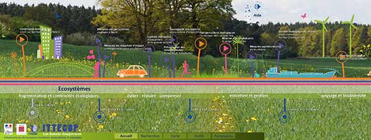
The green and blue weave is a regulatory tool for the preservation of biodiversity that aims to maintain and restore a functional ecological network on the national territory so that animal and plant species can ensure their survival, allowing their movement between favorable habitat patch (reinforcing the policy of protected areas). It must be taken into account in the development projects and in particular during the implementation of the « avoid, reduce, offset » measures. To do this, it is essential to understand the impact of different types of development on the quality of connectivity within landscapes, to ensure a good preservation of biodiversity and therefore the sustainability of human activities that take place there.

However, currently, in the context of ILT projects, there is almost no evaluation of the effectiveness of the « avoid, reduce, offset » sequence in maintaining the metapopulation functioning of bats, and in particular the evaluation of the impact of bats. ILT on gene flow. This is despite the stakes around this globally threatened taxon (Mickleburgh et al., 2002) and the commitments of European countries to restore the conservation status of these species (Flora Fauna Habitat Directive 1992, 2009 [articles 16 and 9]).

It will therefore be necessary, by innovative methods and breaking conventional approaches, to fill gaps in the knowledge of the impact of LTI on rare and endangered species in order to better define biodiversity management policies. .

The objectives are: (i) to provide a better understanding of the knowledge elements that constitute the connectivities in the landscape and (ii) to propose to the building owners a method of evaluation in order to know the effectiveness of the transparency works ecological (frequentation and flow of bats).

The project DÉCHIR is organized around 3 axes:

    Axis 1: Importance of ecological corridors in daily movements;
    Axis 2: Efficiency of aerial structures of ecological transparency (chiropteroducts in particular);
    Axis 3: Effect of linear transport infrastructures on the gene flows of bat populations.

Responsable(s) scientifique(s)
Fabien
CLAIREAU
Muséum national d'Histoire naturelle - UMR 7204 Centre d'Écologie et des Sciences de la Conservation
Organisation:
fabien.claireau@mnhn.fr
Présentation
Valorisations