")


IMPACT (2)
- ITT and Landscape Modeling for Dynamic Impacts Assessment in the Territory
ITT and Landscape Modeling for Dynamic Impacts Assessment in the Territory
The development of a Terrestrial Transport Infrastructure (ITT) generates significant changes and disruptions on all the natural and human components of the territory of insertion.
The consideration of impacts in the implementation of development projects is difficult. There is a strong demand in terms of methods and tools from all the actors involved in these projects (project owners, project managers, local authorities, consultancies, instructors, naturalists) to predict and qualify these impacts.
The overall goal of the IMPACT project is to develop methods and operational tools for assessing the impacts of ITT projects in order to improve environmental decision-making.
To measure these impacts, a TTI project was considered as a factor of modification of the territory that will disturb existing dynamics. From a methodological point of view, this orientation structured the IMPACT project. It was a question of characterizing the territorial dynamics, to determine rules of evolution and to simulate from these rules evolutions with and without ITT.
The IMPACT project was based on a reality, that of the bypass of Nîmes and Montpellier (High Speed Line) in the territory of Costières de Nîmes. The territory of Costières de Nîmes extends south-east of Nîmes, in the department of Gard (Languedoc-Roussillon, France).
Another characteristic of IMPACT was the partnership dimension. From conception to completion, the project has relied on collaborations with local authorities, state services, space managers, naturalist associations, the Chamber of Agriculture, the agency of urban planning and regional development, design offices, the client.
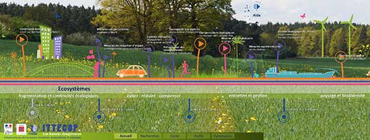
The project was organized in 6 modules. The first module "data mining" wanted to test the use of automatic extraction methods to identify territorial dynamics, distinguishing the evolutions due to the impacts of ITTs. The second module wanted to develop a model of landscape dynamics capable of describing the main processes (territorial, ecological) in progress and to identify evolution rules allowing the third module to simulate future evolutions according to scenarios, including those concerning the implementation of a transport infrastructure. The fourth module wanted to develop a generic, operational and generalizable tool capable of producing simulations and prospective analyzes for assessing the impacts of ITTs on a territory. Module 5 "Ecosystem Systems" explored the value of using ecosystem services to take into account "ordinary biodiversity". Module 6 "decision-making process" examined the decision cycle of an ITT project to identify by which decision-makers, at what points in the cycle and how information could be mobilized to improve biodiversity mainstreaming. of decision.
The modeling and simulation coupling has produced relevant and usable information on the foreseeable evolutions of territories. The project also highlighted the weakness of knowledge about "ordinary biodiversity" and the difficulties of access and sharing of this knowledge. Thus, in the case of the CNM project, the consideration of biodiversity was limited to the management of a remarkable species, protected the bustard.
Continuity is of course through methodological consolidation actions that are in the field of research. For each module, proposals for methodological improvements and research perspectives were proposed. But perhaps in a more fundamental way, the questions of regulatory processes (taking biodiversity into account in the consultation phases upstream of the project before irrevocable decisions), integration to obtain operational tools (meeting the needs of partners) and partnership dialogue (improvement of the phases of consultation and socialization of issues in processes of "citizen pedagogy" ....) are central.
These issues can only be partially addressed as part of a research project. They pose questions of organization of the relations between the services of the State and the private actors, consulting firms, in charge of the production of knowledge and the information.
The IMPACT project is complementary to the INTERMOPES project (APR ITTECOP 2008).